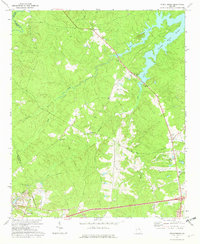
1972 Map of Wrightsboro
USGS Topo · Published 1974About this map
Wrightsboro occupies a central position in this corner of McDuffie County, surrounded by a landscape where agriculture and emerging infrastructure meet. The topography is defined by the branching fingers of Clark Hill Lake in the northeast, which draws water from the Little River and Hart Creek. This 1970s landscape shows the transition from rural church-centered communities to a more modern footprint, evidenced by the presence of the Thomson Airport and the Belle Meade Country Club in the southeast.
Find a feature on this map
26 named features on this map. Tap any name to fly to it.
Don’t see what you’re looking for? This feature index may not catch every label — zoom into the map to look around manually.
Map Details
Editions of this 1972 Wrightsboro Map
3 editions found
Other maps of this area

1892 · Mc Cormick
USGS Topo · 1:125,000

1906 · Crawfordville
USGS Topo · 1:125,000

1912 · Mc Cormick
USGS Topo · 1:125,000

1921 · Appling
USGS Topo · 1:62,500

1922 · Harlem
USGS Topo · 1:62,500

1943 · Appling
USGS Topo · 1:62,500

1948 · Harlem
USGS Topo · 1:62,500

1948 · Thomson East
USGS Topo · 1:24,000

1950 · Dearing
USGS Topo · 1:24,000

1953 · Athens
USGS Topo · 1:250,000