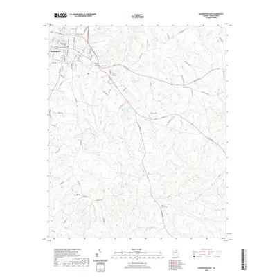
2020 Map of Washington East
USGS Topo · Published 2020About this map
The Wilkes County Courthouse stands as the central landmark of Washington, anchored by a grid of streets including Depot St, Lexington Ave, and S Alexander Ave. The landscape transitions from this urban core into the rural reaches of Wilkes County, where the small settlements of Logan and Lundberg serve as local navigation points. Water shapes the terrain, with several significant reservoirs like Booth Lake, Shillinglaw Lake, and the Washington Country Club Lake dotting the hillsides between the winding paths of Rocky Cr and Threemile Cr. For researchers, the presence of localized burial sites such as Smyrna Cem and Cliffords Grove Cem offers clear points of interest for genealogical study. The map illustrates a contemporary Southern landscape where historic county seat infrastructure meets a network of creeks and small-scale lakes.
Find a feature on this map
79 named features on this map. Tap any name to fly to it.
Don’t see what you’re looking for? This feature index may not catch every label — zoom into the map to look around manually.
Map Details
Editions of this 2020 Washington East Map
This is the sole edition of this map. No revisions or reprints were ever made.
Other maps of this area

1906 · Crawfordville
USGS Topo · 1:125,000

1953 · Athens
USGS Topo · 1:250,000

1954 · Metasville
USGS Topo · 1:24,000

1955 · Tignall
USGS Topo · 1:24,000

1958 · Athens
USGS Topo · 1:250,000

1959 · Athens
USGS Topo · 1:250,000

1963 · Athens
USGS Topo · 1:250,000
1971 · Celeste
USGS Topo · 1:24,000
1972 · Wrightsboro
USGS Topo · 1:24,000
1972 · Aonia
USGS Topo · 1:24,000