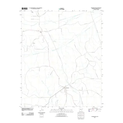
2011 Map of Washington
USGS Topo · Published 2011About this map
Washington and Ozan anchor this part of Hempstead County, where the landscape is defined by the winding tributaries of the Little Missouri River system. The drainage patterns of Middle Fork Ozan Creek and South Fork Ozan Creek show the complex hydrology of the region, including an abandoned Old Channel that indicates how these waterways have shifted over time. In the northwest, Saint Peter Cemetery and Belk Cemetery serve as important landmarks for those tracing local family lineages in this agricultural corridor. The map details a dense network of rural routes, such as Hempstead 22 and County Rd 42, which connect these historic settlements across a terrain carved by High Creek and Town Creek.
Find a feature on this map
55 named features on this map. Tap any name to fly to it.
Don’t see what you’re looking for? This feature index may not catch every label — zoom into the map to look around manually.
Map Details
Editions of this 2011 Washington Map
This is the sole edition of this map. No revisions or reprints were ever made.
Other maps of this area

1951 · Blevins
USGS Topo · 1:24,000

1951 · Columbus
USGS Topo · 1:24,000

1951 · Sheppard
USGS Topo · 1:24,000

1951 · Nashville
USGS Topo · 1:24,000

1951 · Washington
USGS Topo · 1:24,000

1951 · Pisgah
USGS Topo · 1:24,000

1951 · Hope
USGS Topo · 1:24,000

1951 · Mc Nab
USGS Topo · 1:24,000

1951 · McCaskill
USGS Topo · 1:24,000

1953 · El Dorado
USGS Topo · 1:250,000