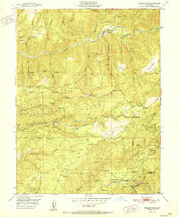
1951 Map of Washington
USGS Topo · Published 1951About this map
The South Fork Yuba River carves through this portion of the northern Sierras, defining a landscape shaped by hydraulic mining and early water infrastructure. Significant gold-era history is visible at Alpha Diggings and Omega Diggings, while the presence of the Blue Lead Mine, Giant King Mine, and Zeibright Mine indicates a deep reliance on the lode and placer deposits of the Tahoe National Forest. Settlement patterns here are tied to elevation and resource extraction, ranging from the town of Washington on the riverbank to mountain outposts like Relief and the White Cloud Guard Sta.
Find a feature on this map
67 named features on this map. Tap any name to fly to it.
Don’t see what you’re looking for? This feature index may not catch every label — zoom into the map to look around manually.
Map Details
Editions of this 1951 Washington Map
2 editions found
Other maps of this area

1891 · Colfax
USGS Topo · 1:125,000

1892 · Colfax
USGS Topo · 1:125,000

1894 · Colfax
USGS Topo · 1:125,000

1898 · Colfax
USGS Topo · 1:125,000

1900 · Colfax
USGS Topo · 1:125,000

1902 · Colfax
USGS Topo · 1:125,000

1938 · Colfax
USGS Topo · 1:125,000

1949 · Chicago Park
USGS Topo · 1:24,000
1949 · North Bloomfield
USGS Topo · 1:24,000
1949 · Pike
USGS Topo · 1:24,000