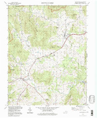
1994 Map of Washington
USGS Topo · Published 1997About this map
Shenandoah National Park dominates the western highland of this Rappahannock County survey, where the Blue Ridge slopes down into a landscape defined by the branching headwaters of the Thornton River and Rush River. The historic village of Washington sits at the junction of several regional routes, serving as a hub near Menefee Mtn and Massies Mtn. Further southwest, Sperryville marks the entrance to Thornton Gap, a critical mountain pass. The rural character of the era is evident in the scatter of small settlements like Rediviva and Smedley, alongside localized industry and community infrastructure such as Fletcher Mill and the County High Sch. This 1990s edition reflects a remarkably stable Piedmont landscape, maintaining its agricultural and residential patterns around family-named landmarks like Jenkins Mountain and Fodder Stack Mtn.
Find a feature on this map
53 named features on this map. Tap any name to fly to it.
Don’t see what you’re looking for? This feature index may not catch every label — zoom into the map to look around manually.
Map Details
Editions of this 1994 Washington Map
This is the sole edition of this map. No revisions or reprints were ever made.
Other maps of this area

1893 · Luray
USGS Topo · 1:125,000

1905 · Luray
USGS Topo · 1:125,000

1929 · Stony Man
USGS Topo · 1:48,000

1933 · Stony Man
USGS Topo · 1:62,500

1939 · Front Royal
USGS Topo · 1:48,000

1944 · Front Royal
USGS Topo · 1:62,500

1947 · Strasburg
USGS Topo · 1:62,500

1949 · Charlottesville
USGS Topo · 1:250,000

1950 · Strasburg
USGS Topo · 1:62,500

1956 · Charlottesville
USGS Topo · 1:250,000