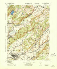
1943 Map of Washington
USGS Topo · Published 1943About this map
Industrial and agricultural activity centers around Washington during the mid-war period, where the intersection of the Delaware Lackawanna and Western RR and the Morris and Essex Div Lackawanna RR drives local commerce. The landscape is marked by manufacturing and extraction, including a Magnetite Mine and the Allen Wood Steel Co near Oxford Furnace. Significant commercial sites like the Pohatcong Hosiery Mills, the Porcelain Co, and a Coca Cola Co bottling facility highlight the town's diverse economic base.
Find a feature on this map
66 named features on this map. Tap any name to fly to it.
Don’t see what you’re looking for? This feature index may not catch every label — zoom into the map to look around manually.
Map Details
Editions of this 1943 Washington Map
This is the sole edition of this map. No revisions or reprints were ever made.
Other maps of this area

1888 · Hackettstown
USGS Topo · 1:62,500

1890 · Easton
USGS Topo · 1:62,500

1890 · High Bridge
USGS Topo · 1:62,500

1891 · Easton
USGS Topo · 1:62,500

1891 · Delaware Water Gap
USGS Topo · 1:62,500

1893 · Delaware Water Gap
USGS Topo · 1:62,500

1894 · Hackettstown
USGS Topo · 1:62,500

1898 · Hackettstown
USGS Topo · 1:62,500

1898 · High Bridge
USGS Topo · 1:62,500

1900 · Raritan
USGS Topo · 1:125,000
Featured Places
- Washington, NJ
- Oxford Township, NJ
- Hope Township, NJ
- Port Murray, Mansfield Township
- Lebanon Township, NJ