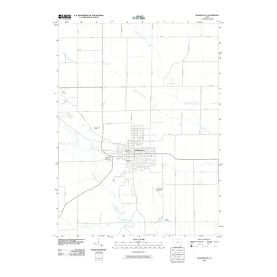
2010 Map of Washington
USGS Topo · Published 2010About this map
Washington serves as the central hub of this Iowa landscape, where a dense grid of streets converges around the Washington Post Office. The town is flanked by essential community landmarks, including the Washington County Fairgrounds to the west and the Washington Municipal Airport to the southeast. This 2010 survey illustrates the town's position within a fertile agricultural region defined by a systematic network of section-line roads like Larch Ave and 200th St.
Find a feature on this map
41 named features on this map. Tap any name to fly to it.
Don’t see what you’re looking for? This feature index may not catch every label — zoom into the map to look around manually.
Map Details
Editions of this 2010 Washington Map
This is the sole edition of this map. No revisions or reprints were ever made.
Other maps of this area

1958 · Davenport
USGS Topo · 1:250,000

1961 · Davenport
USGS Topo · 1:250,000

1962 · Davenport
USGS Topo · 1:250,000

1969 · Kalona
USGS Topo · 1:24,000
1969 · Riverside
USGS Topo · 1:24,000

1969 · Washington
USGS Topo · 1:24,000

1970 · Ainsworth
USGS Topo · 1:24,000
1973 · Wellman
USGS Topo · 1:24,000

1973 · West Chester
USGS Topo · 1:24,000

1980 · Brighton
USGS Topo · 1:24,000