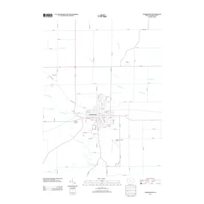
2013 Map of Washington
USGS Topo · Published 2013About this map
The city of Washington serves as the central hub for this part of southeast Iowa, defined by a grid of residential and commercial streets that radiate from the center. The landscape is heavily influenced by the drainage patterns of W Fork Crooked Cr and the branches of Long Creek, including S Fork Long Cr and N Fork Long Cr. These waterways carve through the surrounding agricultural lands, creating a distinct interface between urban development and the rural countryside. Significant local landmarks such as the Washington County Fairgrounds on the west side and the Washington Municipal Airport to the southeast underscore the area's role as a regional gathering point and transportation center. Neighborhoods extend toward family-named developments like Jones Acres Ln, while outlying roads like Larch Ave and Quince Ave mark the transition into the broader Iowa plains.
Find a feature on this map
83 named features on this map. Tap any name to fly to it.
Don’t see what you’re looking for? This feature index may not catch every label — zoom into the map to look around manually.
Map Details
Editions of this 2013 Washington Map
This is the sole edition of this map. No revisions or reprints were ever made.
Other maps of this area

1958 · Davenport
USGS Topo · 1:250,000

1961 · Davenport
USGS Topo · 1:250,000

1962 · Davenport
USGS Topo · 1:250,000

1969 · Kalona
USGS Topo · 1:24,000
1969 · Riverside
USGS Topo · 1:24,000

1969 · Washington
USGS Topo · 1:24,000

1970 · Ainsworth
USGS Topo · 1:24,000
1973 · Wellman
USGS Topo · 1:24,000

1973 · West Chester
USGS Topo · 1:24,000

1980 · Brighton
USGS Topo · 1:24,000