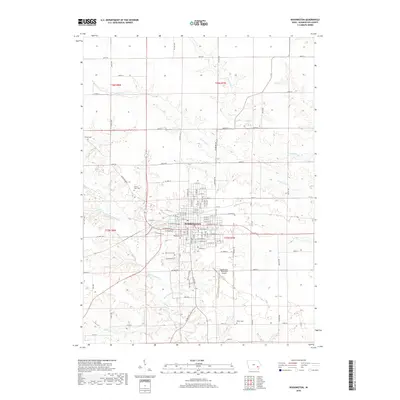
2018 Map of Washington
USGS Topo · Published 2018About this map
The city of Washington serves as the central hub for this part of Southeast Iowa, where a dense grid of streets like W Main St and E Madison St transitions into a landscape of geometric agricultural plots. The area is defined by its dendritic drainage patterns, with the West Fork Crooked Creek and S Fork Long Cr carving through the prairie soil. For genealogists, the map is particularly detailed regarding local burial sites, documenting Woodlawn Cem, Elm Grove Cem, and the uniquely named County Farm Cem northwest of the city center. This late-2010s survey captures the region's modern infrastructure, from the Washington Municipal Airport to the extensive county road network including Riverside Rd and Lexington Blvd, while preserving the traditional township and range divisions of T75N and T76N that have shaped Iowa's land use for generations.
Find a feature on this map
92 named features on this map. Tap any name to fly to it.
Don’t see what you’re looking for? This feature index may not catch every label — zoom into the map to look around manually.
Map Details
Editions of this 2018 Washington Map
This is the sole edition of this map. No revisions or reprints were ever made.
Other maps of this area

1958 · Davenport
USGS Topo · 1:250,000

1961 · Davenport
USGS Topo · 1:250,000

1962 · Davenport
USGS Topo · 1:250,000

1969 · Kalona
USGS Topo · 1:24,000
1969 · Riverside
USGS Topo · 1:24,000

1969 · Washington
USGS Topo · 1:24,000

1970 · Ainsworth
USGS Topo · 1:24,000
1973 · Wellman
USGS Topo · 1:24,000

1973 · West Chester
USGS Topo · 1:24,000

1980 · Brighton
USGS Topo · 1:24,000