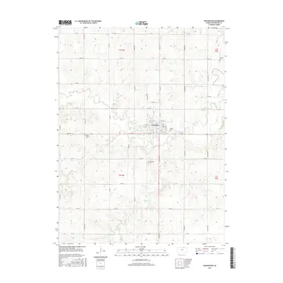
2015 Map of Washington
USGS Topo · Published 2015About this map
Washington serves as the central hub of this Kansas landscape, where a traditional grid of streets like W College St and E 7th St anchors the surrounding agricultural section lines. The terrain is defined by the winding paths of Mill Cr and its tributaries, including Plum Cr and Camp Cr, which carve through the prairie. For those tracing family histories in Washington County, the map identifies several local burial sites, including Emmons Cem in the northeast and Mount Pleasant Cem to the west. A notable natural landmark, Mormon Spring, is located south of the main settlement near Prairie Rd, suggesting the historical importance of reliable water sources in this region. The map also documents the transition from named town streets to the rural road network, where routes like Quivira Rd and Rainbow RD facilitate movement between the homesteads and fields.
Find a feature on this map
47 named features on this map. Tap any name to fly to it.
Don’t see what you’re looking for? This feature index may not catch every label — zoom into the map to look around manually.
Map Details
Editions of this 2015 Washington Map
This is the sole edition of this map. No revisions or reprints were ever made.
Other maps of this area

1889 · Marysville
USGS Topo · 1:125,000

1893 · Washington
USGS Topo · 1:125,000

1894 · Marysville
USGS Topo · 1:125,000

1955 · Manhattan
USGS Topo · 1:250,000

1956 · Manhattan
USGS Topo · 1:250,000

1957 · Manhattan
USGS Topo · 1:250,000
1966 · Washington NW
USGS Topo · 1:24,000

1966 · Morrowville
USGS Topo · 1:24,000

1966 · Washington
USGS Topo · 1:24,000

1966 · Hanover SW
USGS Topo · 1:24,000