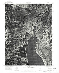
1974 Map of Washoe City
USGS Topo · Published 1977About this map
Washoe Lake dominates the central landscape of this mid-1970s orthophotoquad, captured through aerial photography from July 4, 1974. The visual data provided by the Geological Survey reveals a clear distinction between the older settlement at Washoe City to the north and the expanding residential grid of New Washoe City on the eastern shore. This era represents a period of significant land development in the valley, where the contrast between the flat lakebed and the surrounding terrain of the Steamboat Hills is sharply defined. Genealogists and historians can trace the precise footprint of local roads and suburban growth as they existed fifty years ago, offering a literal image of the Nevada landscape before more modern western expansion shifted the region's character.
Find a feature on this map
4 named features on this map. Tap any name to fly to it.
Don’t see what you’re looking for? This feature index may not catch every label — zoom into the map to look around manually.
Map Details
Editions of this 1974 Washoe City Map
This is the sole edition of this map. No revisions or reprints were ever made.
Other maps of this area

1891 · Carson
USGS Topo · 1:125,000

1893 · Carson
USGS Topo · 1:125,000

1950 · Virginia City
USGS Topo · 1:62,500

1950 · Mt. Rose
USGS Topo · 1:62,500

1952 · Mt. Rose
USGS Topo · 1:62,500

1952 · Virginia City
USGS Topo · 1:62,500

1955 · Marlette Lake
USGS Topo · 1:24,000

1956 · Dayton
USGS Topo · 1:62,500

1956 · Carson City
USGS Topo · 1:62,500

1957 · Reno
USGS Topo · 1:250,000