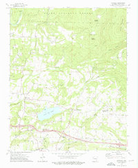
1973 Map of Watalula
USGS Topo · Published 1976About this map
Watalula and the surrounding Arkansas hillsides reflect a mix of timber, gas extraction, and small-scale agriculture in the early 1970s. The landscape is defined by the Ozark National Forest and the winding Mulberry River to the north, while the southern portion of the sheet shows the expansion of Ozark near the Ozark City Lake. Several family-named landmarks provide significant value for genealogists, including McNally Cem, Rogers Cem, and Handchew Cem. An intriguing industrial footprint is visible at the Charcoal Ovens near Enon Ch, while the local economy is further evidenced by a dense Gas Field and numerous Gas Wells peppered throughout the hollows. Evidence of historical transportation remains via the Old Railroad Grade running parallel to the southern boundary, documenting the changing transit patterns of Franklin County before modern highway shifts.
Find a feature on this map
51 named features on this map. Tap any name to fly to it.
Don’t see what you’re looking for? This feature index may not catch every label — zoom into the map to look around manually.
Map Details
Editions of this 1973 Watalula Map
2 editions found
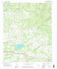
Other maps of this area

1879 · Cravens
USGS Topo · 1:62,500

1887 · Magazine Mountain #1
USGS Topo · 1:62,500

1887 · Magazine Mountain #2
USGS Topo · 1:62,500

1887 · Watalula
USGS Topo · 1:62,500

1887 · Magazine Mountain
USGS Topo · 1:62,500

1890 · Magazine Mountain
USGS Topo · 1:125,000

1906 · Batson
USGS Topo · 1:62,500

1939 · Watalula
USGS Topo · 1:62,500

1956 · Russellville
USGS Topo · 1:250,000

1961 · Coal Hill
USGS Topo · 1:24,000