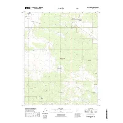
2020 Map of Water Canyon Peak
USGS Topo · Published 2020About this map
Dixie National Forest dominates the high-elevation terrain of southwestern Utah, where the border between Iron and Washington counties cuts through a series of significant canyons and benches. This 2020 survey documents a landscape defined by its vital water sources, with historic springs such as Nephi Spring, Terry Spring, and Dads Spring providing crucial points of interest in an otherwise arid environment. The transition from the Panaca Ridge down into Wide Hollow and Mud Flat reveals the complex drainage patterns of the region, including Shoal Creek and Rattlesnake Creek. Notable landmarks for navigation and land use include the prominent Water Canyon Peak, the expansive Pine Park Bench, and Big Bench. Transportation through this remote section is primarily facilitated by rugged routes like Crestline Rd and the Old Modena Rd, alongside specialized paths like the N Hills Atv Trail and Pine Canyon Trail.
Find a feature on this map
37 named features on this map. Tap any name to fly to it.
Don’t see what you’re looking for? This feature index may not catch every label — zoom into the map to look around manually.
Map Details
Editions of this 2020 Water Canyon Peak Map
This is the sole edition of this map. No revisions or reprints were ever made.
Other maps of this area

1885 · St. George
USGS Topo · 1:250,000

1885 · Pioche
USGS Topo · 1:250,000

1886 · Pioche
USGS Topo · 1:250,000

1891 · St. George
USGS Topo · 1:250,000

1953 · Cedar City
USGS Topo · 1:250,000

1954 · Caliente
USGS Topo · 1:250,000

1958 · Cedar City
USGS Topo · 1:250,000

1958 · Docs Pass
USGS Topo · 1:24,000

1959 · Caliente
USGS Topo · 1:250,000

1962 · Cedar City
USGS Topo · 1:250,000