1985 Map of Water Gap West
USGS Topo · Published 1986About this map
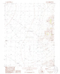
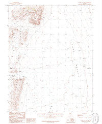
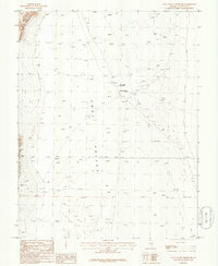
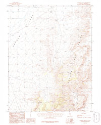
Garden Valley dominates this high-desert basin in southeastern Nevada, where the drainage patterns of Cherry Creek, Sand Creek, and Pine Creek converge. The landscape is defined by the sharp verticality of the Golden Gate Range to the east, contrasting with the wide alluvial floor of the valley. A unique human mark on this isolated terrain is the mention of a Sculpture near an unpaved Landing Strip, indicating an intersection of modern land art or remote installation within the traditional rangeland. The map also records the boundary between Nye and Lincoln Counties as it cuts across the southern portion of the valley. This 1980s field check captures a period of minimal infrastructure, primarily characterized by a network of seasonal watercourses and primitive tracks through the sagebrush.
Find a feature on this map
11 named features on this map. Tap any name to fly to it.
Don’t see what you’re looking for? This feature index may not catch every label — zoom into the map to look around manually.
Map Details
Editions of this 1985 Water Gap West Map
This is the sole edition of this map. No revisions or reprints were ever made.
Other maps of this area
1942 · Penoyer Valley
USGS Topo · 1:125,000

1954 · Caliente
USGS Topo · 1:250,000

1956 · Lund
USGS Topo · 1:250,000

1959 · Caliente
USGS Topo · 1:250,000

1960 · Lund
USGS Topo · 1:250,000
1985 · Adaven
USGS Topo · 1:24,000
1985 · Worthington Peak
USGS Topo · 1:24,000
1985 · Water Gap East
USGS Topo · 1:24,000
1985 · Coal Valley Reservoir
USGS Topo · 1:24,000
1985 · Murphy Gap NW
USGS Topo · 1:24,000