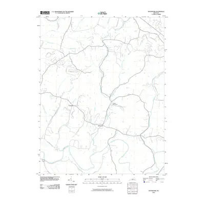
2010 Map of Waterford
USGS Topo · Published 2010About this map
The Waterford and Crenshaw settlements anchor this rural landscape in Spencer and Jefferson counties, where the Salt River carves a broad path through the southern terrain. This 2010 survey reveals a complex network of waterways, with the Plum Creek and its tributary, Little Plum Creek, draining the central valley toward the river. The topography is defined by significant drainage patterns from several runs and creeks, including Broad Run, Dutchman Creek, and the uniquely named Feather Bed Hollow.
Find a feature on this map
41 named features on this map. Tap any name to fly to it.
Don’t see what you’re looking for? This feature index may not catch every label — zoom into the map to look around manually.
Map Details
Editions of this 2010 Waterford Map
This is the sole edition of this map. No revisions or reprints were ever made.
Other maps of this area

1907 · Louisville
USGS Topo · 1:62,500

1929 · Taylorsville
USGS Topo · 1:62,500

1949 · Samuels
USGS Topo · 1:24,000

1949 · Shepherdsville
USGS Topo · 1:62,500

1951 · Jeffersontown
USGS Topo · 1:24,000

1951 · Fisherville
USGS Topo · 1:24,000

1951 · Waterford
USGS Topo · 1:24,000

1951 · Mount Washington
USGS Topo · 1:24,000
1951 · Louisville
USGS Topo · 1:62,500

1953 · Bloomfield
USGS Topo · 1:24,000