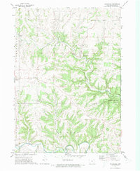
1971 Map of Waterville
USGS Topo · Published 1973About this map
Waterville serves as the central hub of this northeast Iowa landscape, where the meandering waters of Paint Creek cut deep through the surrounding bluffs. The map captures a rural economy defined by scattered settlements like Maud, Rossville, and Egan, alongside multiple quarries that speak to the local geology. In the southern portion of the quadrangle, the Yellow River winds through the Yellow River State Forest, a significant area of public land that includes a dedicated Campground. Cultural markers of the early 1970s are evident in the preservation of community centers like East Paint Creek Ch and St Pius Ch. Transportation history is visible near the river, where an Old Grade indicates a former rail or road alignment through the complex terrain of Dry Hollow and the surrounding townships of Jefferson and Paint Creek.
Find a feature on this map
24 named features on this map. Tap any name to fly to it.
Don’t see what you’re looking for? This feature index may not catch every label — zoom into the map to look around manually.
Map Details
Editions of this 1971 Waterville Map
2 editions found
Other maps of this area

1903 · Waukon
USGS Topo · 1:125,000

1929 · Ferryville
USGS Topo · 1:62,500

1929 · Prairie Du Chien
USGS Topo · 1:62,500

1932 · Ferryville
USGS Topo · 1:62,500

1932 · Prairie Du Chien
USGS Topo · 1:62,500

1958 · La Crosse
USGS Topo · 1:250,000

1961 · La Crosse
USGS Topo · 1:250,000

1965 · La Crosse
USGS Topo · 1:250,000

1966 · Ferryville
USGS Topo · 1:62,500
1967 · Prairie Du Chien
USGS Topo · 1:62,500