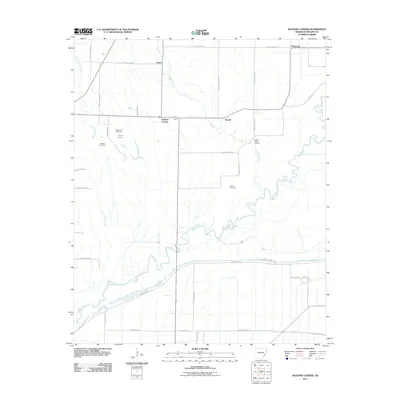
2011 Map of Watkins Corner
USGS Topo · Published 2011About this map
Big Creek and Coffee Creek meander through this section of Phillips County, defining a landscape dominated by agricultural fields and drainage patterns. The rural communities of Watkins Corner, Cypert, and Gobell serve as local anchors, connected by a grid of Phillips and County roads. The terrain is notably flat, punctuated by the low-lying Cargo Slash and Jessie Slough, which illustrate the water-management challenges of the Mississippi Delta region. Genealogists will find significant value in the distribution of family and community burial sites, including Mount Zion Cemetery, Lightfoot Cemetery, Taylor Cemetery, and Coffee Creek Cemetery. These sites, often situated near the small settlements of Kingtown or along the winding banks of Little Cypress Creek, offer a clear spatial record of the area's social history and the enduring legacy of early Arkansas homesteads.
Find a feature on this map
40 named features on this map. Tap any name to fly to it.
Don’t see what you’re looking for? This feature index may not catch every label — zoom into the map to look around manually.
Map Details
Editions of this 2011 Watkins Corner Map
This is the sole edition of this map. No revisions or reprints were ever made.
Other maps of this area

1939 · Modoc
USGS Topo · 1:62,500

1939 · Indian Bay
USGS Topo · 1:62,500

1940 · Marvell
USGS Topo · 1:62,500

1940 · Holly Grove
USGS Topo · 1:62,500

1948 · Helena
USGS Topo · 1:250,000

1948 · Modoc
USGS Topo · 1:62,500

1950 · Helena
USGS Topo · 1:250,000

1954 · Indian Bay
USGS Topo · 1:62,500

1955 · Helena
USGS Topo · 1:250,000

1956 · Marvell
USGS Topo · 1:62,500