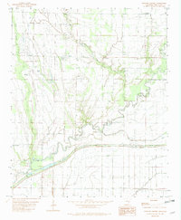
1982 Map of Watkins Corner
USGS Topo · Published 1982About this map
Big Creek meanders across this low-lying Delta landscape in Phillips County, Arkansas, defining the local drainage patterns as it flows toward Johnson Bayou and Cypress Creek. The rural character of the early 1980s is evident in the scattered small settlements like Cypert, Watkins Corner, and Gobell, which are linked by a network of unimproved roads. The map reveals the community-centered layout of the era, with local gathering points such as Mt Zion Ch and New Hope Ch serving residents in the outlying areas.
Find a feature on this map
18 named features on this map. Tap any name to fly to it.
Don’t see what you’re looking for? This feature index may not catch every label — zoom into the map to look around manually.
Map Details
Editions of this 1982 Watkins Corner Map
This is the sole edition of this map. No revisions or reprints were ever made.
Other maps of this area

1939 · Modoc
USGS Topo · 1:62,500

1939 · Indian Bay
USGS Topo · 1:62,500

1940 · Marvell
USGS Topo · 1:62,500

1940 · Holly Grove
USGS Topo · 1:62,500

1948 · Helena
USGS Topo · 1:250,000

1948 · Modoc
USGS Topo · 1:62,500

1950 · Helena
USGS Topo · 1:250,000

1954 · Indian Bay
USGS Topo · 1:62,500

1955 · Helena
USGS Topo · 1:250,000

1956 · Marvell
USGS Topo · 1:62,500