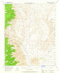
1951 Map of Waucoba Wash
USGS Topo · Published 1966About this map
The Inyo Mountains dominate the western portion of this 1951 survey, giving way to the stark expanse of the Saline Valley (Depression). This landscape is defined by its extreme isolation and a mid-century mining economy focused on specialized minerals. Industrial activity is concentrated in the canyons, where names like the Waucoba Tungsten Mine, White Eagle Talc Mine, and Grey Eagle Talc Mine indicate the diverse geological resources being extracted. Near Willow Creek, the presence of Willow Creek Camp suggests a vital base for operations in this arid environment.
Find a feature on this map
34 named features on this map. Tap any name to fly to it.
Don’t see what you’re looking for? This feature index may not catch every label — zoom into the map to look around manually.
Map Details
Editions of this 1951 Waucoba Wash Map
3 editions found

Other maps of this area

1907 · Mt. Whitney
USGS Topo · 1:125,000

1908 · Lida
USGS Topo · 1:250,000

1908 · Ballarat
USGS Topo · 1:250,000

1913 · Bishop
USGS Topo · 1:125,000

1913 · Lida
USGS Topo · 1:250,000

1913 · Ballarat
USGS Topo · 1:250,000

1919 · Mt. Whitney
USGS Topo · 1:125,000

1937 · Mt. Whitney
USGS Topo · 1:125,000

1947 · Mariposa
USGS Topo · 1:250,000

1948 · Death Valley
USGS Topo · 1:250,000