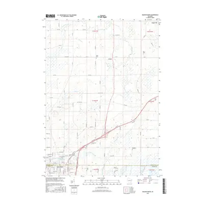
2015 Map of Waupun North
USGS Topo · Published 2015About this map
Waupun marks the southern reach of this 2015 survey, where the South Branch Rock River flows near the municipal center and the waters of Waupun Lake. The surrounding Fond du Lac and Dodge County landscape is defined by its agrarian patterns and numerous small burial grounds that point to the area's 19th-century settlement. Genealogists can find several notable sites including the State Prison Cem and the Norwegian Church Cem. North of the city, the terrain transitions into the wetlands of Gallagher Marsh and the scattered hamlets of Ladoga and Rogersville. This modern topographic study details the branching drainage system of Ladoga Cr and Willow Cr as they feed into the W Br Rock River, illustrating the enduring relationship between the region's watercourses and its established road network.
Find a feature on this map
70 named features on this map. Tap any name to fly to it.
Don’t see what you’re looking for? This feature index may not catch every label — zoom into the map to look around manually.
Map Details
Editions of this 2015 Waupun North Map
This is the sole edition of this map. No revisions or reprints were ever made.
Other maps of this area

1916 · Ripon
USGS Topo · 1:48,000

1918 · Ripon
USGS Topo · 1:62,500

1955 · Waupun
USGS Topo · 1:62,500

1955 · Fox Lake
USGS Topo · 1:62,500

1956 · Ripon
USGS Topo · 1:62,500

1956 · Rosendale
USGS Topo · 1:62,500

1957 · Madison
USGS Topo · 1:250,000

1960 · Madison
USGS Topo · 1:250,000

1975 · Waupun NW
USGS Topo · 1:24,000
1975 · Waupun NE
USGS Topo · 1:24,000