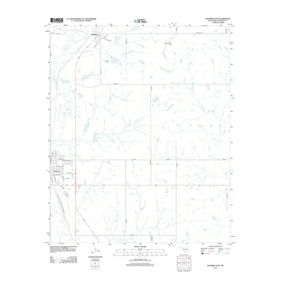
2012 Map of Waurika East
USGS Topo · Published 2012About this map
Addington and the northeastern edges of Waurika anchor this Jefferson County landscape, characterized by a complex network of prairie streams and water management sites. The terrain is defined by the drainages of Cow Cr and Monument Cr, which feed into the Cow Creek Site 2 Reservoir and Cow Creek Site 3 Reservoir. These man-made features reflect mid-to-late 20th-century water conservation efforts common in the Oklahoma plains. To the north, Addington displays a compact grid of streets like 5th St and 6th St, while the Addington Cem serves as a significant landmark for genealogical research. The eastern portion of the map is dominated by the winding path of W Mud Cr and the prominent rise of Monument Hill, offering a clear view of the rural township structure and the distribution of local roads such as Monument RD and E 1960 RD that partition the agricultural land.
Find a feature on this map
31 named features on this map. Tap any name to fly to it.
Don’t see what you’re looking for? This feature index may not catch every label — zoom into the map to look around manually.
Map Details
Editions of this 2012 Waurika East Map
This is the sole edition of this map. No revisions or reprints were ever made.
Other maps of this area

1901 · Addington
USGS Topo · 1:125,000

1955 · Lawton
USGS Topo · 1:250,000

1957 · Hastings
USGS Topo · 1:62,500

1957 · Ardmore
USGS Topo · 1:250,000

1962 · Ryan
USGS Topo · 1:62,500

1962 · Temple
USGS Topo · 1:62,500

1963 · Ardmore
USGS Topo · 1:250,000

1964 · Comanche SE
USGS Topo · 1:24,000

1964 · Comanche
USGS Topo · 1:24,000
1984 · Irving
USGS Topo · 1:24,000