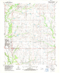
1987 Map of Waurika East
USGS Topo · Published 1988About this map
Waurika serves as a focal point in Jefferson County during the late 1980s, sitting at the junction of the Oklahoma Kansas and Texas railroad and several key highways. This survey illustrates a landscape shaped by historical boundaries and ranching operations, notably featuring the Indian Territory Boundary Line running north-south through the western sections. The terrain is marked by significant drainages including Cow Creek and Beaver Creek, while local landmarks like the Historical Museum and County Hospital reflect the civic development of the era.
Find a feature on this map
22 named features on this map. Tap any name to fly to it.
Don’t see what you’re looking for? This feature index may not catch every label — zoom into the map to look around manually.
Map Details
Editions of this 1987 Waurika East Map
This is the sole edition of this map. No revisions or reprints were ever made.
Other maps of this area

1901 · Addington
USGS Topo · 1:125,000

1955 · Lawton
USGS Topo · 1:250,000

1957 · Hastings
USGS Topo · 1:62,500

1957 · Ardmore
USGS Topo · 1:250,000

1962 · Ryan
USGS Topo · 1:62,500

1962 · Temple
USGS Topo · 1:62,500

1963 · Ardmore
USGS Topo · 1:250,000

1964 · Comanche SE
USGS Topo · 1:24,000

1964 · Comanche
USGS Topo · 1:24,000
1984 · Irving
USGS Topo · 1:24,000