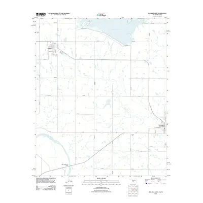
2012 Map of Waurika West
USGS Topo · Published 2012About this map
Waurika and the smaller town of Hastings anchor this 2012 survey along the northern bank of the Red River, where the Oklahoma-Texas state line follows the water's winding path. The landscape is defined by the transition from rural agricultural sections to the managed water systems of Waurika Lake and Beaver Cr. In Hastings, a tight grid of streets like College St and Flynn Ave reflects the organized settlement of the region, while the Hastings Cem north of town provides a focused point for genealogical research.
Find a feature on this map
42 named features on this map. Tap any name to fly to it.
Don’t see what you’re looking for? This feature index may not catch every label — zoom into the map to look around manually.
Map Details
Editions of this 2012 Waurika West Map
This is the sole edition of this map. No revisions or reprints were ever made.
Other maps of this area

1901 · Addington
USGS Topo · 1:125,000

1955 · Lawton
USGS Topo · 1:250,000

1957 · Hastings
USGS Topo · 1:62,500

1957 · Ardmore
USGS Topo · 1:250,000

1962 · Ryan
USGS Topo · 1:62,500

1962 · Temple
USGS Topo · 1:62,500

1963 · Ardmore
USGS Topo · 1:250,000

1964 · Comanche
USGS Topo · 1:24,000

1984 · Hooper
USGS Topo · 1:24,000
1984 · Irving
USGS Topo · 1:24,000