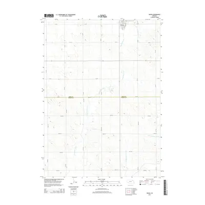
2014 Map of Wausa
USGS Topo · Published 2014About this map
Wausa occupies the northern edge of this survey, where the grid of city streets like S Lincoln St and E Norris St gives way to the broad agricultural landscape of the Nebraska plains. The terrain is defined by the winding course of the N Fork Elkhorn River and its tributary, the E Br N Fork Elkhorn River, which drain south through a network of section-line roads. This map documents the boundary between Knox Co and Pierce Co, highlighting how the political borders of the region align with the 870 Rd corridor. The landscape is characterized by a high density of rural throughways such as 548 Ave and 869th Rd, illustrating the deeply established township-and-range system that organizes the farming properties of north-central Nebraska.
Find a feature on this map
23 named features on this map. Tap any name to fly to it.
Don’t see what you’re looking for? This feature index may not catch every label — zoom into the map to look around manually.
Map Details
Editions of this 2014 Wausa Map
This is the sole edition of this map. No revisions or reprints were ever made.
Other maps of this area

1955 · Sioux City
USGS Topo · 1:250,000

1958 · Sioux City
USGS Topo · 1:250,000

1959 · Sioux City
USGS Topo · 1:250,000

1963 · Foster
USGS Topo · 1:24,000

1963 · Osmond
USGS Topo · 1:24,000

1968 · Hartington SW
USGS Topo · 1:24,000

1968 · Bloomfield SE
USGS Topo · 1:24,000

1971 · Wausa
USGS Topo · 1:24,000
1971 · Randolph SW
USGS Topo · 1:24,000
1971 · Magnet
USGS Topo · 1:24,000