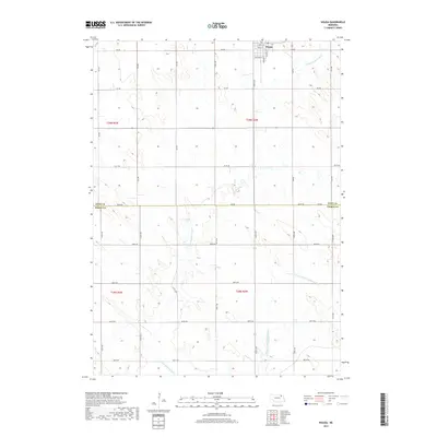
2017 Map of Wausa
USGS Topo · Published 2017About this map
Wausa occupies the northern edge of this agricultural landscape, where the town plat is defined by a grid of streets including Norris St, Grant St, and Pershing St. The surrounding terrain in northeastern Nebraska is characterized by the headwaters and drainage of the Elkhorn River system. The N Fork Elkhorn River and the E Br North Fork Elkhorn River meander through the sections, following the natural contours of the land. This 2017 survey illustrates the precise section lines and county boundaries that divide the region, specifically the line between Knox and Pierce Counties. The map detail captures the intersection of rural section roads like 870th Rd and 549th Ave, providing a clear view of the modern land divisions and watercourses that have shaped this farming community.
Find a feature on this map
31 named features on this map. Tap any name to fly to it.
Don’t see what you’re looking for? This feature index may not catch every label — zoom into the map to look around manually.
Map Details
Editions of this 2017 Wausa Map
This is the sole edition of this map. No revisions or reprints were ever made.
Other maps of this area

1955 · Sioux City
USGS Topo · 1:250,000

1958 · Sioux City
USGS Topo · 1:250,000

1959 · Sioux City
USGS Topo · 1:250,000

1963 · Foster
USGS Topo · 1:24,000

1963 · Osmond
USGS Topo · 1:24,000

1968 · Hartington SW
USGS Topo · 1:24,000

1968 · Bloomfield SE
USGS Topo · 1:24,000

1971 · Wausa
USGS Topo · 1:24,000
1971 · Randolph SW
USGS Topo · 1:24,000
1971 · Magnet
USGS Topo · 1:24,000