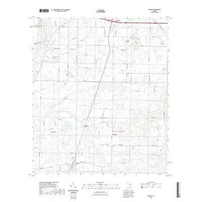
2021 Map of Wausau
USGS Topo · Published 2021About this map
The town of Wausau serves as a southern anchor for this portion of Washington County, where the landscape is defined by a complex network of bays, swamps, and creek systems. Moving north through Bells Mill, the terrain is heavily punctuated by distinct water features such as Cobb Bay Pond and the headwaters of Hard-Labor Cr. This environment reflects a history of small-scale agriculture and timber, with family-named sites like Hartzog Field and several community landmarks including the Shiloh Baptist Cem near the northern border. The eastern section around Bradford and Orange Hill shows a more rolling topography leading toward Falling Water Hill. These features, along with names like Douglas Ferry Rd, point to an era when local commerce and travel were intrinsically tied to navigating the wet lowlands and the various mills that once operated along these Florida panhandle streams.
Find a feature on this map
125 named features on this map. Tap any name to fly to it.
Don’t see what you’re looking for? This feature index may not catch every label — zoom into the map to look around manually.
Map Details
Editions of this 2021 Wausau Map
This is the sole edition of this map. No revisions or reprints were ever made.
Other maps of this area

1950 · Vernon
USGS Topo · 1:24,000

1950 · Chipley
USGS Topo · 1:24,000

1950 · Wausau
USGS Topo · 1:24,000

1950 · Gap Lake
USGS Topo · 1:24,000

1950 · Poplar Head
USGS Topo · 1:24,000

1951 · Chipley
USGS Topo · 1:24,000

1951 · Wausau
USGS Topo · 1:24,000
1951 · Poplar Head
USGS Topo · 1:24,000

1951 · Bonifay
USGS Topo · 1:24,000

1951 · Gap Pond
USGS Topo · 1:24,000