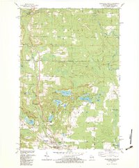
1982 Map of Wausaukee North
USGS Topo · Published 1983About this map
The Chicago and North Western railroad corridor shapes the development of this Marinette County landscape, connecting the village of Wausaukee with the small northern settlement of Cedarville. The terrain is defined by a complex drainage system where the Pike River and Wausaukee River converge toward the Menominee River at the Michigan border. Along these waterways, evidence of local recreation and community life is clear at Daves Falls County Park and Evergreen Park.
Find a feature on this map
35 named features on this map. Tap any name to fly to it.
Don’t see what you’re looking for? This feature index may not catch every label — zoom into the map to look around manually.
Map Details
Editions of this 1982 Wausaukee North Map
This is the sole edition of this map. No revisions or reprints were ever made.
Other maps of this area

1939 · Pembine
USGS Topo · 1:48,000

1939 · Dunbar
USGS Topo · 1:48,000

1940 · Athelstane
USGS Topo · 1:48,000

1941 · Dunbar
USGS Topo · 1:48,000

1942 · Athelstane
USGS Topo · 1:48,000

1942 · Wausaukee
USGS Topo · 1:48,000

1947 · Pembine
USGS Topo · 1:48,000

1947 · Dunbar
USGS Topo · 1:48,000

1947 · Wausaukee
USGS Topo · 1:48,000

1954 · Iron Mountain
USGS Topo · 1:250,000