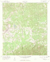
1955 Map of Waverly Hall
USGS Topo · Published 1959About this map
Waverly Hall serves as the central hub of this mid-century survey, situated at the junction of the Southern railroad line and local road networks. The landscape is characterized by a series of small, dispersed settlements including Banghville and Ridgeway, alongside numerous rural institutions that speak to the area's social fabric. Genealogy researchers will find significant value in the distribution of family and community landmarks, such as Pitts Memorial Ch, St Johns Cem, and the Laney Sch.
Find a feature on this map
29 named features on this map. Tap any name to fly to it.
Don’t see what you’re looking for? This feature index may not catch every label — zoom into the map to look around manually.
Map Details
Editions of this 1955 Waverly Hall Map
3 editions found
Other maps of this area

1907 · Talbotton
USGS Topo · 1:125,000

1934 · Warm Springs
USGS Topo · 1:62,500

1936 · Warm Springs
USGS Topo · 1:62,500

1949 · Midland
USGS Topo · 1:24,000

1949 · Upatoi
USGS Topo · 1:24,000

1950 · Talbotton
USGS Topo · 1:24,000

1950 · Geneva
USGS Topo · 1:24,000

1950 · Waverly Hall
USGS Topo · 1:24,000

1950 · Cataula
USGS Topo · 1:24,000

1950 · Talbotton
USGS Topo · 1:62,500