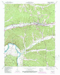
1950 Map of Waverly
USGS Topo · Published 1988About this map
The town of Waverly serves as the central hub of this mid-century survey, situated where the Broadway of America highway and the CSX railroad corridor follow the valley of Trace Creek. The landscape transitions from the urbanized streets around Waverly Central High Sch to the winding waters of the Duck River and the sprawling Kentucky Lake in the west. This riverine environment is defined by significant conservation and historical sites, including the Tennessee National Wildlife Refuge and the Hugh Link Farm State Archaeological Area. Numerous family burial grounds such as Carnell Cem, McAdoo Cem, and Vaden Cem are scattered throughout the surrounding hollows like Pennywinkle Hollow and Arnold Hollow, reflecting a deeply rooted rural settlement pattern. The map also documents local infrastructure of the era, from the Sewage Disposal facility to the Waverly Hospital and several lookout and radio towers.
Find a feature on this map
89 named features on this map. Tap any name to fly to it.
Don’t see what you’re looking for? This feature index may not catch every label — zoom into the map to look around manually.
Map Details
Editions of this 1950 Waverly Map
4 editions found
Other maps of this area

1936 · Gorman
USGS Topo · 1:24,000

1936 · Hurricane Mills
USGS Topo · 1:24,000

1936 · Woolworth
USGS Topo · 1:24,000

1936 · Bucksnort
USGS Topo · 1:24,000

1936 · Halls Creek
USGS Topo · 1:24,000

1936 · Johnsonville
USGS Topo · 1:24,000

1936 · Harmon Creek
USGS Topo · 1:24,000

1936 · Waverly
USGS Topo · 1:24,000

1936 · Hustburg
USGS Topo · 1:24,000

1949 · Harmon Creek
USGS Topo · 1:24,000