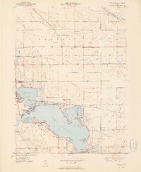
1951 Map of Wawasee
USGS Topo · Published 1951About this map
Lake Wawasee and its neighboring Syracuse Lake form the centerpiece of this mid-century portrait of Kosciusko County, Indiana. The landscape is a mix of recreational shorelines and a highly developed drainage system of agricultural ditches such as Hire Ditch and Blue Ditch. The town of Syracuse is visible on the western shore, served by the Baltimore and Ohio railroad line that skirts the northern edges of the lakes.
Find a feature on this map
53 named features on this map. Tap any name to fly to it.
Don’t see what you’re looking for? This feature index may not catch every label — zoom into the map to look around manually.
Map Details
Editions of this 1951 Wawasee Map
2 editions found
Other maps of this area

1950 · Leesburg
USGS Topo · 1:24,000

1950 · North Webster
USGS Topo · 1:24,000

1951 · Milford
USGS Topo · 1:24,000

1951 · Wawasee
USGS Topo · 1:24,000

1951 · Ormas
USGS Topo · 1:24,000

1953 · Fort Wayne
USGS Topo · 1:250,000

1956 · Fort Wayne
USGS Topo · 1:250,000

1956 · Ligonier
USGS Topo · 1:24,000

1959 · Topeka
USGS Topo · 1:24,000

1959 · Millersburg
USGS Topo · 1:24,000