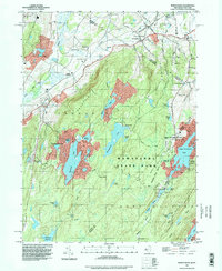
1994 Map of Wawayanda
USGS Topo · Published 1998About this map
Wawayanda State Park and the Abram S Hewitt State Forest dominate this landscape on the New Jersey-New York border, preserving a network of lakes and ridgelines. The Appalachian Trail winds across Wawayanda Mountain and Pochuck Mountain, following the high ground above the Vernon Valley. In the lowlands, the settlement at Vernon and the lakeside community of Highland Lakes mark the primary residential areas, while smaller hamlets like Glenwood and DeKays are tucked along the winding roads of the interior. The presence of older institutional sites, such as District School No 8 near New Milford and the Twp Sch, alongside traditional landmarks like the Greenwood Ch, indicates a settled rural corridor. This mid-century imagery also captures the recreational character of the region, from the extensive waters of Wawayanda Lake and Upper Greenwood Lake to a local Drive-in Theater near the state line.
Find a feature on this map
83 named features on this map. Tap any name to fly to it.
Don’t see what you’re looking for? This feature index may not catch every label — zoom into the map to look around manually.
Map Details
Editions of this 1994 Wawayanda Map
This is the sole edition of this map. No revisions or reprints were ever made.
Other maps of this area

1888 · Franklin
USGS Topo · 1:62,500

1891 · Greenwood Lake
USGS Topo · 1:62,500

1893 · Greenwood Lake
USGS Topo · 1:62,500

1894 · Franklin
USGS Topo · 1:62,500

1897 · Franklin
USGS Topo · 1:62,500

1903 · Franklin Furnace
USGS Topo · 1:62,500

1903 · Greenwood Lake
USGS Topo · 1:62,500

1906 · Port Jervis
USGS Topo · 1:62,500

1906 · Goshen
USGS Topo · 1:62,500

1908 · Goshen
USGS Topo · 1:62,500