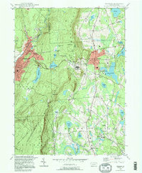
1994 Map of Waymart
USGS Topo · Published 1996About this map
The Moosic Mountains dominate this landscape, creating a high divide between the industrial activity of the Lackawanna River valley and the rural tablelands of Wayne County. In the west, the city of Carbondale and the village of Simpson sit along the Lackawanna River, where the presence of a strip mine and a Shaft indicate the area's deep anthracite roots. Moving east across the ridge past High Knob, the map reveals a shift toward institutions and recreation. The State Correctional Inst is a prominent landmark near Waymart, while the surrounding hills are dotted with significant religious and educational sites like St Nicholas Seminary and the Western Monastery. The eastern plateau is characterized by numerous glacial bodies of water, including Keen Lake and Lake Ladore, which serve as focal points for the community alongside smaller settlements like South Canaan.
Find a feature on this map
52 named features on this map. Tap any name to fly to it.
Don’t see what you’re looking for? This feature index may not catch every label — zoom into the map to look around manually.
Map Details
Editions of this 1994 Waymart Map
This is the sole edition of this map. No revisions or reprints were ever made.
Other maps of this area

1889 · Scranton
USGS Topo · 1:62,500

1891 · Scranton
USGS Topo · 1:62,500

1892 · Honesdale
USGS Topo · 1:62,500

1892 · Dundaff
USGS Topo · 1:62,500

1893 · Scranton
USGS Topo · 1:62,500

1928 · Ariel
USGS Topo · 1:62,500

1932 · Ariel
USGS Topo · 1:62,500

1943 · Scranton
USGS Topo · 1:125,000

1943 · Honesdale
USGS Topo · 1:125,000

1946 · Olyphant
USGS Topo · 1:24,000