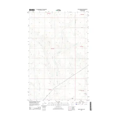
2014 Map of Wayne Creek NW
USGS Topo · Published 2014About this map
The hydrological network of Wayne Cr dominates this landscape in northern Montana, where its numerous branches create a complex system of drainages across the terrain. This 2014 survey reveals a sparse road network, primarily consisting of Mt-241 running diagonally through the southern sections, supported by local routes like Violet Rd and Murray Coulee Rd. The land is defined by its natural water features and topographical depressions, including Aveil Ravine and Harts Coulee near the southern boundary. To the east, the headwaters of W Savoy Cr begin to carve into the plains. The map's detail is focused on these drainage patterns, from the E Fork Wayne Cr to the S Fork Wayne Cr, illustrating the vital role of these waterways in the regional geography.
Find a feature on this map
16 named features on this map. Tap any name to fly to it.
Don’t see what you’re looking for? This feature index may not catch every label — zoom into the map to look around manually.
Map Details
Editions of this 2014 Wayne Creek NW Map
This is the sole edition of this map. No revisions or reprints were ever made.
Other maps of this area

1903 · Wayne Creek
USGS Topo · 1:62,500

1905 · Wayne Creek
USGS Topo · 1:62,500

1905 · Harlem
USGS Topo · 1:62,500

1913 · Cherry Ridge
USGS Topo · 1:125,000

1953 · Havre
USGS Topo · 1:250,000

1957 · Havre
USGS Topo · 1:250,000

1958 · Havre
USGS Topo · 1:250,000

1964 · Wayne Creek SE
USGS Topo · 1:24,000
1964 · Grable Coulee
USGS Topo · 1:24,000
1964 · Harlem
USGS Topo · 1:24,000