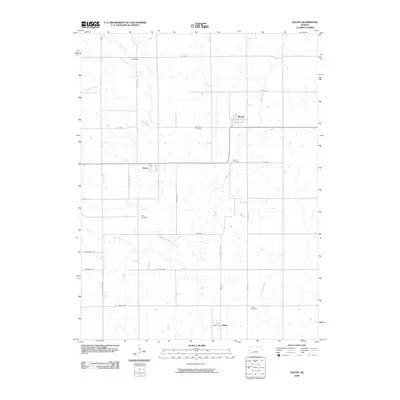
2009 Map of Wayne
USGS Topo · Published 2009About this map
Wayne and Talmo anchor this agricultural landscape in Republic County, defined by a network of rural section roads and the meandering drainage of Salt Creek. The map reveals a high density of burial grounds for a rural township, including Frontier Cemetery in the north and Zion Cemetery to the south, which serve as critical markers for family history researchers and genealogists tracing early prairie pioneers. The terrain is shaped by several watercourses like Turkey Creek and Coal Creek, which influence the local road grid, as seen in the alignment of Co RD 21 and Republic RD. Near the southern border, the small settlement of Hollis sits adjacent to Hollis Cemetery, reflecting the classic Kansas pattern of small-town centers established alongside quiet creek bottoms like Little Upton Creek.
Find a feature on this map
35 named features on this map. Tap any name to fly to it.
Don’t see what you’re looking for? This feature index may not catch every label — zoom into the map to look around manually.
Map Details
Editions of this 2009 Wayne Map
This is the sole edition of this map. No revisions or reprints were ever made.
Other maps of this area

1892 · Concordia
USGS Topo · 1:125,000

1893 · Washington
USGS Topo · 1:125,000

1955 · Manhattan
USGS Topo · 1:250,000

1956 · Manhattan
USGS Topo · 1:250,000

1957 · Manhattan
USGS Topo · 1:250,000

1965 · Wayne
USGS Topo · 1:24,000

1965 · Concordia NW
USGS Topo · 1:24,000
1965 · Clyde
USGS Topo · 1:24,000

1965 · Agenda
USGS Topo · 1:24,000
1965 · Rice
USGS Topo · 1:24,000