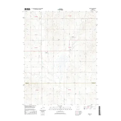
2015 Map of Wayne
USGS Topo · Published 2015About this map
Wayne and Talmo anchor this rural landscape along the border of Republic and Cloud Counties, where the terrain is defined by a dense network of watercourses. The drainage of Salt Cr dominates the western half of the map, while Coal Cr, Turkey Cr, and Little Upton Cr carve through the eastern sections. This 2015 survey reveals a strictly maintained section-line road grid, including routes like Republic Rd and Co Rd 350, which connect a series of legacy landmarks central to the region's genealogy. Numerous burial grounds are scattered throughout the townships, including Frontier Cem in the north and Hollis Cem in the south. The presence of Salt Creek Trl and Zion Trl suggests long-established corridors of travel through this agricultural heartland, reaching toward the Zion Cem and Rose Hill Cem.
Find a feature on this map
37 named features on this map. Tap any name to fly to it.
Don’t see what you’re looking for? This feature index may not catch every label — zoom into the map to look around manually.
Map Details
Editions of this 2015 Wayne Map
This is the sole edition of this map. No revisions or reprints were ever made.
Other maps of this area

1892 · Concordia
USGS Topo · 1:125,000

1893 · Washington
USGS Topo · 1:125,000

1955 · Manhattan
USGS Topo · 1:250,000

1956 · Manhattan
USGS Topo · 1:250,000

1957 · Manhattan
USGS Topo · 1:250,000

1965 · Wayne
USGS Topo · 1:24,000

1965 · Concordia NW
USGS Topo · 1:24,000
1965 · Clyde
USGS Topo · 1:24,000

1965 · Agenda
USGS Topo · 1:24,000
1965 · Rice
USGS Topo · 1:24,000