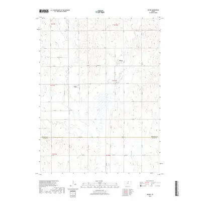
2018 Map of Wayne
USGS Topo · Published 2018About this map
Agricultural lands and seasonal waterways define this portion of North Central Kansas at the boundary of Republic Co and Cloud Co. The landscape is anchored by the small community of Wayne and the nearby settlement of Talmo, both of which serve as nodes in a network of section-line roads and named rural lanes like Wayne Ln and Talmo Ln. For genealogists, the map is particularly valuable for its documentation of several well-distributed burial grounds, including Frontier Cem in the north and Hollis Cem in the south, which often represent the early pioneer families of the township. Drainage follows the subtle topography of the Great Plains, with Salt Cr, Coal Cr, and Turkey Cr carving gentle valleys through the wheat and corn fields. Historical pathways like Salt Creek Trl and Zion Trl indicate the persistence of older routes within the modern grid system.
Find a feature on this map
47 named features on this map. Tap any name to fly to it.
Don’t see what you’re looking for? This feature index may not catch every label — zoom into the map to look around manually.
Map Details
Editions of this 2018 Wayne Map
This is the sole edition of this map. No revisions or reprints were ever made.
Other maps of this area

1892 · Concordia
USGS Topo · 1:125,000

1893 · Washington
USGS Topo · 1:125,000

1955 · Manhattan
USGS Topo · 1:250,000

1956 · Manhattan
USGS Topo · 1:250,000

1957 · Manhattan
USGS Topo · 1:250,000

1965 · Wayne
USGS Topo · 1:24,000

1965 · Concordia NW
USGS Topo · 1:24,000
1965 · Clyde
USGS Topo · 1:24,000

1965 · Agenda
USGS Topo · 1:24,000
1965 · Rice
USGS Topo · 1:24,000