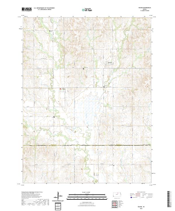
2022 Map of Wayne
USGS Topo · Published 2022About this map
The agricultural plains of north-central Kansas are defined here by a network of drainage creeks and scattered rural burying grounds. Small clusters of settlement at Wayne and Talmo serve as the primary hubs in an area otherwise dominated by section-line roads and family farms. The landscape is carved by winding waterways including Salt Cr, Coal Cr, and Turkey Cr, which likely dictated the earliest patterns of land division and homesteading. Genealogy researchers will find several well-preserved local landmarks, including Frontier Cem in the north and Hollis Cem at the southern edge of the quadrangle. The presence of Rose Hill Cem, Union Cem, and Zion Cem suggests the historical locations of early pioneer congregations and rural communities that once thrived along the border of Republic Co and Cloud Co. Local travel is documented along routes such as Salt Creek Trl and Zion Trl.
Find a feature on this map
33 named features on this map. Tap any name to fly to it.
Don’t see what you’re looking for? This feature index may not catch every label — zoom into the map to look around manually.
Map Details
Editions of this 2022 Wayne Map
This is the sole edition of this map. No revisions or reprints were ever made.
Other maps of this area

1892 · Concordia
USGS Topo · 1:125,000

1893 · Washington
USGS Topo · 1:125,000

1955 · Manhattan
USGS Topo · 1:250,000

1956 · Manhattan
USGS Topo · 1:250,000

1957 · Manhattan
USGS Topo · 1:250,000

1965 · Wayne
USGS Topo · 1:24,000

1965 · Concordia NW
USGS Topo · 1:24,000
1965 · Clyde
USGS Topo · 1:24,000

1965 · Agenda
USGS Topo · 1:24,000
1965 · Rice
USGS Topo · 1:24,000