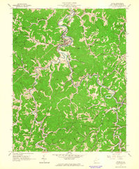
1962 Map of Wayne
USGS Topo · Published 1963About this map
Twelvepole Creek defines the rugged landscape of Wayne County in the early 1960s, winding through the township borders of Union, Stonewall, and Lincoln. The central settlement of Wayne serves as the hub of this rural corridor, where the Norfolk and Western railway follows the river's curves through the deep valleys. The map reveals a high density of extraction activity, with numerous gas wells and several small mines near East Lynn and Armilda.
Find a feature on this map
70 named features on this map. Tap any name to fly to it.
Don’t see what you’re looking for? This feature index may not catch every label — zoom into the map to look around manually.
Map Details
Editions of this 1962 Wayne Map
3 editions found
Other maps of this area

1892 · Huntington
USGS Topo · 1:125,000

1898 · Huntington
USGS Topo · 1:125,000

1901 · Guyandot
USGS Topo · 1:62,500

1901 · Ceredo
USGS Topo · 1:62,500

1902 · Guyandot
USGS Topo · 1:62,500

1903 · Kenova
USGS Topo · 1:125,000

1904 · Kenova
USGS Topo · 1:125,000

1909 · Wayne
USGS Topo · 1:62,500

1911 · Louisa
USGS Topo · 1:48,000

1913 · Ceredo
USGS Topo · 1:62,500