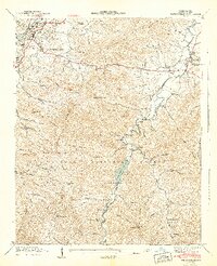
1942 Map of Waynesville
USGS Topo · Published 1942About this map
Waynesville and Hazelwood serve as the primary population centers in this 1940s-era topographic survey, situated at the confluence of the Southern railroad and Richland Creek. The map documents a transition from the industrial and residential corridors of the valley floor to the steep, densely wooded slopes of the Pisgah National Forest. Along the West Fork Pigeon River, the settlement at Sunburst and the Daniel Boone Camp highlight the area's timber and recreational history, while the Big Ridge Mine on the western heights indicates the region's mineral extraction efforts.
Find a feature on this map
85 named features on this map. Tap any name to fly to it.
Don’t see what you’re looking for? This feature index may not catch every label — zoom into the map to look around manually.
Map Details
Editions of this 1942 Waynesville Map
2 editions found
Other maps of this area

1891 · Cowee
USGS Topo · 1:125,000

1893 · Mt Guyot
USGS Topo · 1:125,000

1894 · Asheville
USGS Topo · 1:125,000

1897 · Cowee
USGS Topo · 1:125,000

1901 · Asheville
USGS Topo · 1:125,000

1905 · Pisgah
USGS Topo · 1:125,000

1906 · Pisgah
USGS Topo · 1:125,000

1907 · Cowee
USGS Topo · 1:125,000

1912 · Mt Guyot
USGS Topo · 1:125,000

1935 · Cruso
USGS Topo · 1:24,000