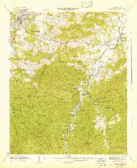
1942 Map of Waynesville
USGS Topo · Published 1942About this map
Waynesville and Hazelwood serve as the primary population centers on this 1942 survey, situated along the Southern railroad line and Richland Creek. To the south, the landscape rises into the Pisgah National Forest, a terrain of high ridges and deep gaps defined by the headwaters of the Pigeon River. The map captures a moment when timber and recreation infrastructure intersected, evidenced by the presence of Sunburst and the Daniel Boone Camp near the West Fork Pigeon River.
Find a feature on this map
84 named features on this map. Tap any name to fly to it.
Don’t see what you’re looking for? This feature index may not catch every label — zoom into the map to look around manually.
Map Details
Editions of this 1942 Waynesville Map
2 editions found
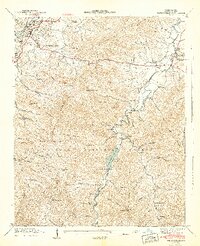
Other maps of this area

1891 · Cowee
USGS Topo · 1:125,000

1893 · Mt Guyot
USGS Topo · 1:125,000

1894 · Asheville
USGS Topo · 1:125,000

1897 · Cowee
USGS Topo · 1:125,000

1901 · Asheville
USGS Topo · 1:125,000

1905 · Pisgah
USGS Topo · 1:125,000

1906 · Pisgah
USGS Topo · 1:125,000

1907 · Cowee
USGS Topo · 1:125,000

1912 · Mt Guyot
USGS Topo · 1:125,000

1935 · Cruso
USGS Topo · 1:24,000