
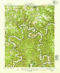
1944 Map of Waynesville
USGS Topo · Published 1944About this map
The Gasconade River carves deep, dramatic loops through the Ozark Plateau, defining the landscape of central Pulaski County during the early 1940s. These serpentine meanders created prominent landmarks like Portuguese Point and Yellow Bluffs, where the river's path is constrained by limestone bluffs and karst topography. The era's settlement pattern is evident in the numerous small country schools and family cemeteries, such as Gaddy Sch and the Vaughn Cem, which served a rural population before the mid-century consolidation.
Find a feature on this map
105 named features on this map. Tap any name to fly to it.
Don’t see what you’re looking for? This feature index may not catch every label — zoom into the map to look around manually.
Map Details
Editions of this 1944 Waynesville Map
2 editions found
Other maps of this area

1888 · Tuscumbia
USGS Topo · 1:125,000

1894 · Tuscumbia
USGS Topo · 1:125,000

1912 · Rolla
USGS Topo · 1:62,500

1933 · Iberia
USGS Topo · 1:62,500

1936 · Waynesville
USGS Topo · 1:48,000

1937 · Iberia
USGS Topo · 1:62,500

1937 · Edgar Springs
USGS Topo · 1:48,000

1937 · Vienna
USGS Topo · 1:62,500

1938 · Vienna
USGS Topo · 1:48,000

1941 · Big Piney
USGS Topo · 1:62,500