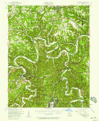
1954 Map of Waynesville
USGS Topo · Published 1958About this map
The Gasconade River winds through the heart of the Missouri Ozarks in this mid-century survey, creating dramatic loops such as the one near Portuguese Point. The landscape is defined by the massive footprint of the Fort Leonard Wood Military Reservation to the south, while the northern section is dominated by the town of Dixon and the St Louis-San Francisco railroad line. Local history is deeply etched into the hills through numerous small community centers like Gospel Ridge and Clementine. Genealogists will find a wealth of family landmarks, including the Wickersham Cemetery, Haller Cemetery, and several rural schools such as Highpoint School and Needmore School. The map captures the region before extensive modern development, showing the original river crossings at Riddle Bridge and the industrial presence of Wheeler Mill near the Big Piney River.
Find a feature on this map
77 named features on this map. Tap any name to fly to it.
Don’t see what you’re looking for? This feature index may not catch every label — zoom into the map to look around manually.
Map Details
Editions of this 1954 Waynesville Map
2 editions found
Other maps of this area

1888 · Tuscumbia
USGS Topo · 1:125,000

1894 · Tuscumbia
USGS Topo · 1:125,000

1912 · Rolla
USGS Topo · 1:62,500

1933 · Iberia
USGS Topo · 1:62,500

1936 · Waynesville
USGS Topo · 1:48,000

1937 · Iberia
USGS Topo · 1:62,500

1937 · Edgar Springs
USGS Topo · 1:48,000

1937 · Vienna
USGS Topo · 1:62,500

1938 · Vienna
USGS Topo · 1:48,000

1941 · Big Piney
USGS Topo · 1:62,500