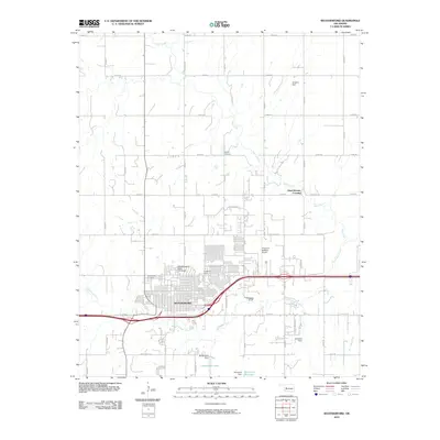
2010 Map of Weatherford
USGS Topo · Published 2010About this map
The city of Weatherford serves as the focal point of this Custer County landscape, characterized by the sprawling campus of Southwestern State University and a grid of rural section-line roads. The Interstate 40 corridor cuts through the southern portion of the city, passing near the Northpark Shops and Greenwood Cemetery. Beyond the urban center, the terrain is defined by the winding paths of Deer Creek and Little Deep Creek, which feed into several local water bodies including Sportsman Lake and Hunnicutt Reservoir. Local history and folklore are anchored by distinctive site names such as Dead Women Crossing to the northeast and Bradley Cemetery situated in the northern agricultural fields. The infrastructure of the area is further evidenced by the Thomas P Stafford Airport and a series of water management structures like Laughlin Dam and Buckmaster Dam.
Find a feature on this map
52 named features on this map. Tap any name to fly to it.
Don’t see what you’re looking for? This feature index may not catch every label — zoom into the map to look around manually.
Map Details
Editions of this 2010 Weatherford Map
This is the sole edition of this map. No revisions or reprints were ever made.
Other maps of this area

1955 · Clinton
USGS Topo · 1:250,000

1956 · Cordell
USGS Topo · 1:62,500

1957 · Clinton
USGS Topo · 1:250,000

1957 · Clinton
USGS Topo · 1:62,500

1961 · Eakly
USGS Topo · 1:62,500

1964 · Weatherford
USGS Topo · 1:62,500

1976 · Clinton SE
USGS Topo · 1:24,000

1976 · Clinton NE
USGS Topo · 1:24,000
1983 · Corn
USGS Topo · 1:24,000
1983 · Indianapolis
USGS Topo · 1:24,000