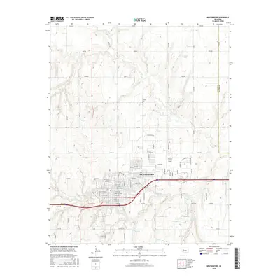
2016 Map of Weatherford
USGS Topo · Published 2016About this map
Southwestern Oklahoma State Univ anchors the western edge of Weatherford, Oklahoma, in this 2016 survey. The city's grid-like development is clearly visible, showing the expansion of residential and commercial districts around the campus and the Interstate 40 corridor. To the northeast, the Thomas P Stafford Airport reflects the region's aviation infrastructure, while local reservoirs like Laughlin Lake, Johnston Reservoir, and Hunnicutt Reservoir highlight the managed water resources essential to the Custer County landscape.
Find a feature on this map
102 named features on this map. Tap any name to fly to it.
Don’t see what you’re looking for? This feature index may not catch every label — zoom into the map to look around manually.
Map Details
Editions of this 2016 Weatherford Map
This is the sole edition of this map. No revisions or reprints were ever made.
Other maps of this area

1955 · Clinton
USGS Topo · 1:250,000

1956 · Cordell
USGS Topo · 1:62,500

1957 · Clinton
USGS Topo · 1:250,000

1957 · Clinton
USGS Topo · 1:62,500

1961 · Eakly
USGS Topo · 1:62,500

1964 · Weatherford
USGS Topo · 1:62,500

1976 · Clinton SE
USGS Topo · 1:24,000

1976 · Clinton NE
USGS Topo · 1:24,000
1983 · Corn
USGS Topo · 1:24,000
1983 · Indianapolis
USGS Topo · 1:24,000