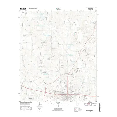
2016 Map of Weatherford North
USGS Topo · Published 2016About this map
Weatherford anchors the southern portion of this Parker County landscape, showing the city's northward expansion alongside historical settlements like Peaster, Greenwood, and the distinct elevation of Oyster Hill. The terrain is defined by a dense network of tributaries including Willow Creek, Town Creek, and Sanchez Creek, which feed into numerous numbered reservoirs and named bodies such as Sunshine Lake. This mid-2010s survey captures the region's transition from the dense urban grid of the county seat to the sprawling rural acreage and cattle country to the north. Local history is preserved through sites like Mount Carmel Cemetery and Greenwood Cemetery, while the presence of the Flying K Airport and Cross Wind Airport highlights the importance of private aviation in this part of North Texas. The map detail reflects a landscape of small water-management reservoirs, winding ranch roads, and local landmarks like Stimson Springs.
Find a feature on this map
196 named features on this map. Tap any name to fly to it.
Don’t see what you’re looking for? This feature index may not catch every label — zoom into the map to look around manually.
Map Details
Editions of this 2016 Weatherford North Map
This is the sole edition of this map. No revisions or reprints were ever made.
Other maps of this area

1891 · Weatherford
USGS Topo · 1:125,000

1893 · Weatherford
USGS Topo · 1:125,000

1931 · Dennis
USGS Topo · 1:62,500

1932 · Springtown
USGS Topo · 1:62,500

1954 · Dallas
USGS Topo · 1:250,000

1958 · Dallas
USGS Topo · 1:250,000

1958 · Springtown
USGS Topo · 1:24,000
1959 · Lake Weatherford
USGS Topo · 1:24,000
1959 · Weatherford North
USGS Topo · 1:24,000
1959 · Brock
USGS Topo · 1:24,000