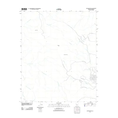
2011 Map of Weaver Peak
USGS Topo · Published 2011About this map
Weaver Peak and Ritter Peak anchor this high desert landscape in Yavapai County, where the terrain is defined by a series of branching drainages and isolated summits. The map captures a moment of transition where the remote open range meets modern residential growth, particularly in the southeast. While much of the area remains dominated by the watershed of Cottonwood Creek and the North Fork Date Creek, the lower elevations show a dense network of private ranch roads and subdivision streets. This shift is evident in the cluster of labels near S Country Club Dr and S Frontier Rd, contrasting with established agricultural landmarks like W Double Bar A Ranch Rd. The inclusion of Rocky Boy Peak and various washes, including Poplar Wash, provides a detailed look at the hydrology that has historically dictated settlement and access in this part of Arizona.
Find a feature on this map
26 named features on this map. Tap any name to fly to it.
Don’t see what you’re looking for? This feature index may not catch every label — zoom into the map to look around manually.
Map Details
Editions of this 2011 Weaver Peak Map
This is the sole edition of this map. No revisions or reprints were ever made.
Other maps of this area

1887 · Prescott
USGS Topo · 1:250,000

1892 · Prescott
USGS Topo · 1:250,000

1903 · Congress
USGS Topo · 1:125,000

1904 · Congress
USGS Topo · 1:125,000

1947 · Kirkland
USGS Topo · 1:62,500

1947 · Wagoner
USGS Topo · 1:62,500

1948 · Kirkland
USGS Topo · 1:63,360

1948 · Wagoner
USGS Topo · 1:63,360

1950 · Wagoner
USGS Topo · 1:62,500
1950 · Kirkland
USGS Topo · 1:62,500