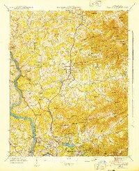
1943 Map of Weaverville
USGS Topo · Published 1943About this map
Weaverville serves as the central hub of this mid-century mountain landscape, situated within a dense network of upland farms and valley settlements just north of Asheville. The topography is defined by the steep ridges of the Elk Mountains and Brittain Mountain, where narrow coves like Mundy Cove and Brittain Cove have fostered tight-knit communities centered around local institutions. Numerous country churches and schools are mapped, including Clarks Chapel, Rays Chapel, and the Brittain Cove Sch, reflecting the importance of neighborhood centers in this era.
Find a feature on this map
95 named features on this map. Tap any name to fly to it.
Don’t see what you’re looking for? This feature index may not catch every label — zoom into the map to look around manually.
Map Details
Editions of this 1943 Weaverville Map
2 editions found
Other maps of this area

1894 · Asheville
USGS Topo · 1:125,000

1900 · Mount Mitchell
USGS Topo · 1:125,000

1901 · Asheville
USGS Topo · 1:125,000

1902 · Mount Mitchell
USGS Topo · 1:125,000

1935 · Barnardsville
USGS Topo · 1:24,000

1935 · Craggy Pinnacle
USGS Topo · 1:24,000

1936 · Marshall
USGS Topo · 1:24,000

1936 · Enka
USGS Topo · 1:24,000

1936 · Weaverville
USGS Topo · 1:24,000

1936 · Mars Hill
USGS Topo · 1:24,000