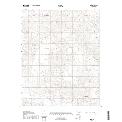
2018 Map of Webb
USGS Topo · Published 2018About this map
The Canadian River cuts through the southwestern corner of this Dewey County landscape, defining the topography of the region. Much of the surrounding terrain is etched by a dense network of drainage systems, including Teepee Cr, Bull Cr, and Panther Cr, which feed into the larger river basin. The small settlement of Webb serves as a local focal point in the eastern portion of the quadrangle, connected to the surrounding countryside by a grid of rural routes such as n2120 RD and e0750 RD. Family and community history is preserved in several small burial grounds scattered across the townships, including Webb Cem, Riverview Cem, Yake Cem, and Halcomb Cem. These sites, often located near seasonal watercourses like Sand Cr or Burnt Cr, provide essential landmarks for genealogists and local historians tracing the settlement patterns of western Oklahoma.
Find a feature on this map
32 named features on this map. Tap any name to fly to it.
Don’t see what you’re looking for? This feature index may not catch every label — zoom into the map to look around manually.
Map Details
Editions of this 2018 Webb Map
This is the sole edition of this map. No revisions or reprints were ever made.
Other maps of this area

1955 · Clinton
USGS Topo · 1:250,000

1955 · Woodward
USGS Topo · 1:250,000

1957 · Clinton
USGS Topo · 1:250,000

1958 · Woodward
USGS Topo · 1:250,000

1961 · Leedey
USGS Topo · 1:62,500

1962 · Aledo
USGS Topo · 1:62,500

1969 · Mutual SW
USGS Topo · 1:24,000

1969 · Lenora
USGS Topo · 1:24,000

1969 · Camargo
USGS Topo · 1:24,000

1984 · Foss Reservoir
USGS Topo · 1:100,000