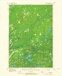
1955 Map of Webb Lake
USGS Topo · Published 1964About this map
The Namekagon River and the St Croix River converge in this mid-century survey of Northwest Wisconsin, defining a landscape of glacial kettle lakes and dense marshland. The settlement pattern reflects the transition from early timbering and pioneer farming toward a forest-management economy, marked by the presence of the Dairyland Lookout Tower and Riverside Lookout Tower. Local life is anchored at crossroads like Cozy Corner and Woodland Corner, while the northern township of Dairyland features established community markers including Covenant Ch and the Dairyland Cem. Genealogists may find particular value in the dispersed rural sites like Swiss Cem and the Webb Lake Sch (Abandoned), which suggest the shifting populations of townships like Blaine and Swiss as small school districts consolidated and farmsteads were reclaimed by the woodland.
Find a feature on this map
77 named features on this map. Tap any name to fly to it.
Don’t see what you’re looking for? This feature index may not catch every label — zoom into the map to look around manually.
Map Details
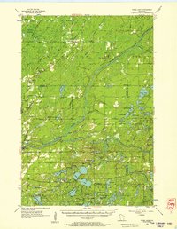
Editions of this 1955 Webb Lake Map
2 editions found
Other maps of this area

1945 · Solon Springs
USGS Topo · 1:48,000

1947 · Minong
USGS Topo · 1:48,000
1948 · Spooner
USGS Topo · 1:48,000

1949 · Danbury
USGS Topo · 1:48,000

1949 · Solon Springs
USGS Topo · 1:48,000

1949 · Hertel
USGS Topo · 1:48,000

1949 · Holyoke
USGS Topo · 1:48,000

1949 · Minong
USGS Topo · 1:48,000

1949 · Webb Lake
USGS Topo · 1:48,000

1949 · Patzau
USGS Topo · 1:48,000