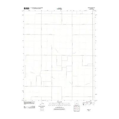
2010 Map of Webb
USGS Topo · Published 2010About this map
Webb occupies the northeast corner of this high plains landscape, situated within a rectilinear grid of agricultural roads in Baca County. The terrain is defined by the intermittent drainage of Little Bear Creek, which meanders across the southern half of the quadrangle, and North Bear Creek, which cuts through the central section. This 2010 survey illustrates the highly organized section-line road system typical of the Colorado eastern plains, featuring thoroughfares such as County Road H and County Road XX. The sparse distribution of named features reflects the remote, pastoral character of the region during the early 21st century, where the landscape is primarily partitioned for ranching or dryland farming. Researchers can trace the specific intersections of these secondary routes, including County Rd-32 and County Road D, which provided the primary connectivity for this isolated community.
Find a feature on this map
22 named features on this map. Tap any name to fly to it.
Don’t see what you’re looking for? This feature index may not catch every label — zoom into the map to look around manually.
Map Details
Editions of this 2010 Webb Map
This is the sole edition of this map. No revisions or reprints were ever made.
Other maps of this area

1891 · Albany
USGS Topo · 1:125,000

1893 · Albany
USGS Topo · 1:125,000

1955 · La Junta
USGS Topo · 1:250,000

1958 · La Junta
USGS Topo · 1:250,000
1966 · Two Butte Springs
USGS Topo · 1:24,000
1966 · Durkee Creek SE
USGS Topo · 1:24,000

1968 · La Junta
USGS Topo · 1:250,000
1968 · North Plum Creek SE
USGS Topo · 1:24,000
1971 · Lycan SE
USGS Topo · 1:24,000
1971 · Lycan NE
USGS Topo · 1:24,000